In The Gulf, A Marsh Thrives as a River Runs Through It
By Rocky Kistner. Cross-posted from NRDC Switchboard.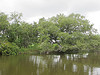
Down here in the bayou of southern Plaquemines Parish, there’s a secret environmental treasure few people see. It’s a magical world hidden by giant cargo vessels that ply the dredged Mississippi River channel, cruising slowly from the Gulf to the commercial docks of New Orleans. On the east side of the river, a fragile marsh and its diverse wildlife thrives, belying the oily assault taking place just a few miles away.
Nurtured and protected by fresh river water that courses through several diversions in the massive Mississippi levy system, this area is a Garden of Eden compared to the destroyed wetlands on the west side where fresh water is walled off by the levies. A patchwork of oil and gas canals have shredded this marsh, flooding it with ocean water to the point it has disappeared. Thousands of acres of rich coastal marsh have been lost where deer, raccoon, alligator and wild hogs roamed, where thousands of migratory birds wintered and fed each year, where untold millions of fish and shrimp spawned. Gone in just a few decades, disappearing rapidly before everyone's eyes. Now just oyster beds and a few hunting camps on stilts remain.
But on the east side of the river, the story is not tragic. It is in fact rejuvenating. It is the reason why Buras-based fisherman and hunting guide Ryan Lambert stays and fights for it each year. It’s why most people settled here and struggled each year through hurricane and heat. After living here and working on the oil disaster over the past four months, I now understand why.
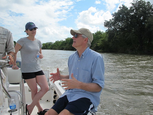
At Ryan’s urging last week, NRDC executive director Peter Lehner and a group of NRDC staff and supporters decided to take a look. We boarded a 25 ft open cabin boat on the Mississippi River just a stone’s throw from NRDC’s Gulf Resource Center in Buras. Captain Joe DiMarco eased the boat out into the mammoth muddy river, slowing down to avoid a tug boat and barge churning down the river.
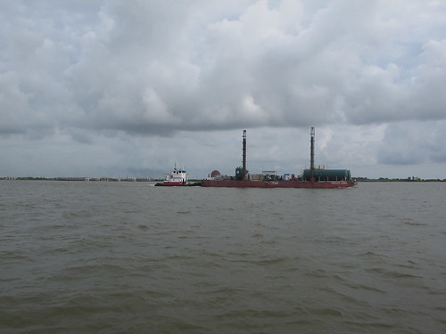
Still, the continent’s largest river is not as wide as you’d expect, perhaps a quarter of a mile. It would probably expand by several miles were it not for Army Corps of Engineer levies that block the river’s natural flow to the Gulf. Instead, marsh-building, silt-rich river water is shunted south from here in a straight line about 20 miles into the Gulf, creating huge dead zones due to the overload of chemicals and fertilizers deposited in one place.
But we are not thinking about that now. We are going where the river water is allowed to leak through the levy walls to reach the marshes. We cruise across the Mississippi, choppy with a stiff southeast wind, to a small 30 ft opening in the levy. “Hang on,” Captain Joe yells. “We need to run the current a little.”
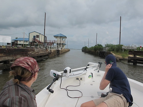
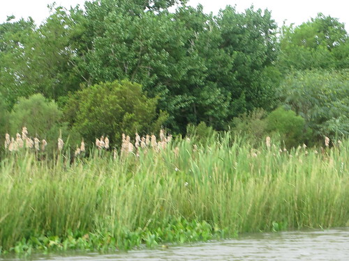
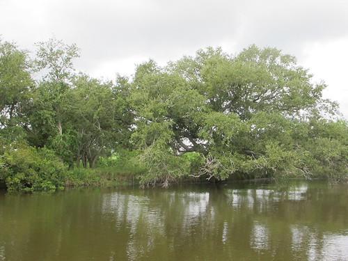
He guns the engine to make a run at small lock that is buttressed by stone blocks. Soon we blast through the tiny opening and enter a new world on the east side of the levy, a bayou lush with plants of elephant ear, duck potato (whose roots taste like coconut), bull marsh grass and Roseau cane, cattails, and wild pea plants. It's an environment strikingly different from the flooded marshes west of the river.
We are like Dorothy stepping through the door of her tornado-flung house. We have found Oz and all its colors. Here the fresh water of the Mississippi River sustains a natural marsh nurtured by the flow of land building silt and mud. In October, Pintail, Teal and Gadwall ducks in the hundreds of thousands to to feed in these waters.
We motor quickly down a 30 ft. dredged gas and oil pipeline that cuts straight through the marsh. The banks are filled with live oak and sweet gum trees, nurtured by the silt flowing in from the river water. Here the silt ends up where nature intended it to go, no longer part of the 120 million tons of sediment that is jettisoned by the river levy into the Gulf each year. The results are astonishing. Night herons, snowy egrets, blue herons, and blue winged teals take flight from the marsh banks. The wetlands here are full of life.

Capt. Joe DiMarco did not grow up here, but he used to come down as a child with his dad, an oil field employee who cut pipeline canals in the marshes near here. He remembers it only too well. “It was great fishing back then and I loved coming down here. But now I realize these canals have destroyed these marshes.”
The oil and gas pipeline canals are easy to spot. They’re the ones that run straight and wide through the marsh. Occasional warning signs run along the banks of gas-filled pipes that crisscross the muddy bottom. Each man-made pipeline cut has expanded in the water like a festering sore, tearing apart the fabric of the marshes.
NRDC’s Peter Lehner remembers seeing these pipelines from flying overhead, straight lines like someone threw uncooked spaghetti onto a plate. “A death of a thousand cuts,” he says.
But here, the fresh water has been able to work its magic; the marshes that hug the river are healthy and solid. We speed up toward Bay Allen and come across natural meandering canals that curve gracefully into the verdant marsh. The water becomes clearer and less brown, filtered by grass and plants.
A persimmon tree loaded with fruit appears on a bank. It’s the source of a favorite medicinal Cajun beverage, persimmon wine, not available in grocery stores. A small cattle barge sits along the banks, where locals move their cows through the marsh like Cajun cowboys driving herds through a pasture. We cruise near a small island called Wild Pecan Island, where pecan trees drop nuts for creatures of the marsh. Soon we find the source of this fertility, Bayou Lamogue, a man-made diversion of river water that cuts under the levy and brings a life sustaining flow of fresh water and silt into the marsh. It bubbles through an underground canal.
Not far away in another wetland area, a huge live oak that spreads its branches majestically into the sky. Below a few small alligators poke their noses out of the water, waiting for unsuspecting prey. We head to a fishing hole, where our captain has caught many a redfish and trout. Catfish, the the scavengers of the salt marsh, are the first to bite.
Here the river water runs free, feeding one of the worlds’ greatest marshes. The water pushes through, protecting the marsh from the poisons washing ashore not far away. Without the river water these wetlands will die. In the Gulf, it already is disappearing at an astounding rate, two football fields an hour. The great levies built to tame the Mississippi for shipping interests are choking off the flow of marsh-nurturing silt, allowing seawater to drown one of the world's greatest environmental treasures. They are killing the life-sustaining nursery of the Gulf.
But in this area, the water is clean and the wetlands are vibrant. We are witness to a marsh that is thriving because a river runs through it. In a region reeling from the oil disaster, it’s comforting to know this place exists. It’s a sanctuary we all need to see. Then you will know why we need to let it grow.
Rocky Kistner is NRDC’s communication associate in their Gulf Resource Center in Buras, LA. Before working with NRDC, he spent more than 20 years as a journalist working on investigative projects and stories for major print and broadcast media outlets.